Using CISL resources, MESACLIP generates exceptionally high-resolution climate data
MESACLIP simulations bring the Earth system into sharper focus than ever before.
MESACLIP is an unprecedented, massive, and freely available dataset for the scientific community, featuring high-resolution Earth system simulations developed using CISL resources. It allows for new insights into climate variability and future regional changes.
MESACLIP, a collaborative effort between scientists from Texas A&M University and NSF NCAR, utilized the computational resources of two major supercomputers. The project leveraged both CISL’s Derecho supercomputer, located at the NCAR-Wyoming Supercomputing Center (NWSC), and the Frontera supercomputer at the Texas Advanced Computing Center (TACC).
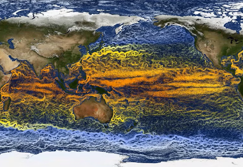
The complexity of the Earth system typically requires climate models to run at lower resolutions, as explicitly resolving features smaller than 100 kilometers is computationally expensive for simulations spanning decades or centuries. However, such lower-resolution models cannot explicitly capture finer-scale features like tropical cyclones or mountain ridges.
MESACLIP overcame this limitation by using the NSF NCAR-based Community Earth System Model (CESM) to run simulations at an unprecedented high resolution—25 kilometers for the atmosphere, and three to ten kilometers for the ocean—for large ensembles of runs.
This achievement was driven by recent advances in supercomputing speed. Extensive model runs on the Derecho supercomputer were instrumental, and upon completion, these model runs will have utilized approximately 25% of that supercomputer’s annual capacity for scientific research. The resulting dataset weighs in at over six petabytes and spans more than 4,500 years of past, present, and future climate.
The MESACLIP modeling reconstructs historical climate from 1850 and projects future climate conditions up to the year 2100, based on a range of greenhouse gas emission scenarios. Early results are already yielding new insights, demonstrating the value of this finer resolution.
For instance, the high-resolution simulations suggest the Atlantic Meridional Overturning Circulation is likely to continue shielding Europe from frigid temperatures, a finding that contradicts suggestions from some lower-resolution models. Furthermore, the modeling successfully reproduced a recent trend of cooling temperatures in the Southern and eastern Pacific Oceans, a trend that lower-resolution models failed to capture.
The publicly-released dataset empowers researchers to tackle a wide range of climate questions that require both high spatial resolution and long simulations, significantly enhancing the scientific community's view of the Earth system.
The work was funded by the National Science Foundation.
To learn more about MESACLIP, see the full news story from UCAR News.